
Access Considerations for Birding Locations
This information is designed to help you decide if a particular birding trail or other location might be a good place to hold an accessible bird outing, or to help you complete a Birdability Site Review to populate the Birdability Map. Websites and recommendations from park staff are frequently incomplete — and so unreliable — sources of a location’s true accessibility, and what is accessible for one user may not be accessible for another.
The Americans with Disabilities Act (1990) sets clear guidelines for the built environment to improve access for people with disabilities. The Americans with Disabilities Act Standards are enforceable by law and apply to newly constructed commercial, and state and local government facilities. Additionally, the Architectural Barriers Act Accessibility Guidelines: Outdoor Developed Areas (2013) apply to some components of trails on federal lands. Both these laws are incredibly important, but they do not cover everything. Just because a facility is ADA compliant does not mean that everyone with a disability will be able to access it. According to the Braunability Drive for Inclusion Report Card 2020, only 15% of people with mobility challenges are satisfied with the effectiveness of ADA laws. The ADA Standards should be considered the minimum — a great start, but there’s a lot more to it!
The list below has been compiled by an occupational therapist after consultation with birders and nature lovers who have various disabilities and other health concerns, and covers a broad range of users. However, there is always more to learn, and Birdability makes no claim that this is an exhaustive list of access considerations for every possible user.
Finally, it is important to keep in mind that no one can predict what an individual with an accessibility challenge can or cannot do… sometimes, not even the person themselves. Even if a location is not ADA-compliant, it may still be accessible for you. We encourage a sense of exploration for folks with access challenges; if a location appears to be reasonably accessible for your needs, please don’t let someone else’s assessment of you prevent you from trying it out. As Virginia Rose, founder of Birdability and a manual wheelchair user says, “You won’t know until you go!”
This list is set out following the order of the Birdability Site Review, in order to help explain why these features matter to various birders. To access the printable, screen reader accessible Birdability Site Review, click here.
General access
Is there a fee to enter the state park, nature center or location? Are discounts available to certain people, or on certain dates?
Is there a fee to park?
Is the trail near or on a public transit route? Many people with disabilities, including those who are legally blind, cannot drive. Is there a way for them to get to the trail?
Distance
What is the distance of the trail? Some people need shorter trails, e.g. 0.5 – 2 miles (0.8 – 3km); others may want longer trails so they can keep on birding!
Is the trail a loop, out-and-back, or ‘lollipop’? A ‘lollipop’ trail goes out one way, then has a loop at the end. Trail users will then retrace their tracks on the initial portion of the trail.
Trail information and signage
Is trail accessibility information available ahead of time via the location’s website? Many websites state they have an “accessible trail”, but this is not enough detail for most potential visitors.
Do signs include technical accessibility information about the trail? An “accessible” trail may be accessible to one person, but not another. Providing this level of detail of information for trail users to make their own informed decisions is ideal!
Trail distance.
Surface type (see below for more).
Slope/gradient/running slope: how steep the trail is. (See below for more detail.) Maximum gradient and average gradient are both really helpful to know.
Cross slope: how much of an angle trail users will be on as they travel down the trail. This can be particularly important to wheelchair and scooter users, who do not want to tip over!
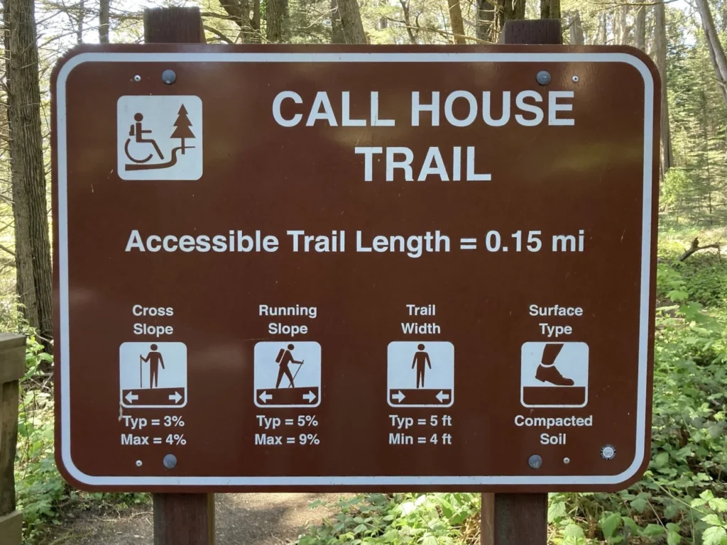
Trail sign with key accessibility information. Call House Trail, Fort Ross State Historic Park, California. Photo: Dal Leite.
At the minimum, does the sign have an easily readable map with trail distances?
Are benches and rest areas marked on the map, with distances in between indicated? Folks who need to rest will be grateful to know ahead of time how far they must travel.
If colors are used to indicate different trails, are symbols used too? Folks with colorblindness may not be able to tell the difference between the ‘green trail’ and the ‘red trail’, but will have more success if, for example, the ‘green trail’ also has circles along the line, and the ‘red trail’ has triangles.
Is there accessible and accurate signage at the trailhead and at any trail intersections? Detailed signs at trail intersections allow visitors to make informed decisions about continuing or turning back.